Shape the future of Kilkenny City
Kilkenny Sustainable Urban Mobility Plan

The Sustainable Urban Mobility Plan (SUMP) is designed to meet the mobility needs of people and businesses in and around Kilkenny City. The plan will introduce measures relating to how people move around the city. This includes street design, public transport and safer walking and cycling infrastructure. The aim of the plan is to make Kilkenny a more vibrant, accessible, healthier and sustainable city for everyone.
The SUMP builds on the work and vision of the overall City and County Development Plan and carefully considers how mobility is best integrated with other initiatives happening.
Why Do We Need a Sustainable Urban Mobility Plan?
Kilkenny City is the fourth-largest settlement in the Southern Region with a population of 27,184 (Census, 2022) and has now become the sixth-largest employment centre in the state. Further significant population growth is projected, and lots of different solutions are required to manage the mobility needs of this growing population. The targets specified in the Development Plan for 2040 are to reduce the number of trips by private car to 40% of total trips to the city and increase the share of walking, public transport and cycling to 35%, 15% and 10% respectively. To accommodate this, space will need to be reallocated in the city to allow for safer walking, wheeling and cycling and to accommodate reliable and attractive public transport services.
A sustainable urban mobility plan has a multitude of other benefits:
Fighting climate change - A Sustainable, Resilient City
Ireland’s transport carbon emissions have become the second largest source of CO2 emissions by sector (IEA, 2022) and Ireland’s goal is to halve greenhouse gas emissions by 2030. Replacing car journeys, where possible, with public transport and active travel will help reach this target.
Allocation of space for greening, street trees, sustainable urban drainage systems or parklets can help create habitat, recreational and biodiversity areas as well as managing temperatures and surface water.Health Improvements
Liveable Cities
Independent Mobility
Economic Benefits
Road Safety
Measures that will increase road safety include raised crossing points, narrowing of carriageways, continuous footpaths and tightening of junctions to slow traffic speeds.
The Process So Far
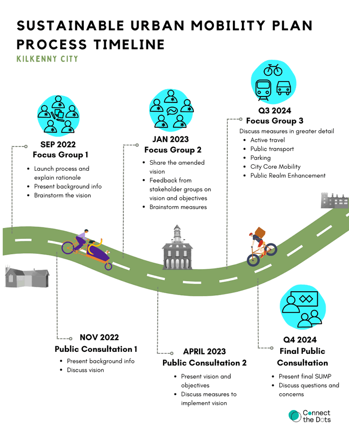
Since 2022, the SUMP has been through multiple rounds of consultation with the public and key stakeholder groups. Another period of consultation will take place before the end of 2024, before the plans are finalised. Details of this will be publicised soon.
For more information on the consultation process to date, and detailed feedback reports, you can visit the consultation page.
Latest Project Updates
Kilkenny County Council has focused on the development of the 10-minute city over the last two iterations of the Development Plan. The initiatives described are currently being implemented or are in the planning stages. These projects focus on regeneration of the city centre, the creation of quality public realm and improved walkability and accessibility of the city centre.
Placemaking Initiatives
Abbey Quarter
The Abbey Quarter is located on the site of the former Smithwick’s Brewery on the banks of the River Nore. This site was originally settled in the 13th century by Franciscan monks who established St. Francis Abbey. The monks brewed ales here long before John Smithwick established his brewery in the early 1700s and it continued to operate as a brewery for 300 years until it was closed by its owner Diageo in 2014.
The remains of the choir and bell tower of St. Francis Abbey still stand on the site today as a reminder of its rich history. Following closure of the Brewery, the site was purchased by Kilkenny County Council. Following a period of public consultation, a dedicated master plan was adopted to guide development of the former brewery site and adjacent lands.
Kilkenny County Council aims to create an urban design layout and architectural framework for a socially inclusive and sustainable mixed-use quarter in Kilkenny City. Amongst the first buildings to open in the Abbey Quarter is the Mayfair Library. The Old Mayfair ballroom was transformed into a state-of-the-art library incorporating dedicated areas for children, teenagers and general leisure reading, computer and study areas, meeting rooms and exhibition areas. A purpose-built blended work-space, with a footfall of over 650 employees, home to Tirlán is also located within the Abbey Quarter, alongside an Urban Park and Skate Park.
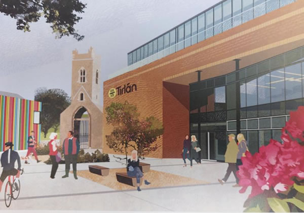
Illustration by Roger O'Reilly
Watergate Urban Park
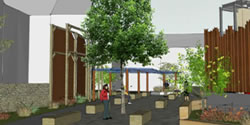
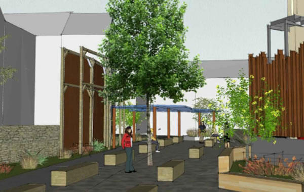
The Watergate Park project aims to create a flexible, multi-functional urban park along Horse Barrack Lane, catering to both daily use and events. The park will provide a permeable link from Abbey Street and Parliament Street to the adjacent Abbey Quarter and River Nore. Sheltered areas, such as canopies, will be provided and raised and a roofed stage will be built to support outdoor performances, complete with the necessary structural integrity for temporary lighting and sound equipment. Public lighting will ensure the park's safe use throughout the day, and feature and coloured lighting will enhance the park's night-time aesthetics and ambience. Future parking will include two e-charging bays, a disabled bay, and a few short-term spaces for local business customers. The design incorporates feedback from various festival committees, organisers, and the Watergate Theatre’s management. This led to a slightly curved walking and cycling route to soften the park's layout, subtly differentiating it from other paved areas. The seating area features dynamic, pivoting seats that can be rearranged for performances while keeping the route clear for cyclists and pedestrians. Some benches will include back and arm rests to be age-friendly. Nature based solutions will be incorporated to manage drainage. This project envisions a multi-functional, aesthetically pleasing space that adapts to various uses, ensuring both everyday utility and special event capabilities.
St. Mary’s Lane Enhancement Scheme
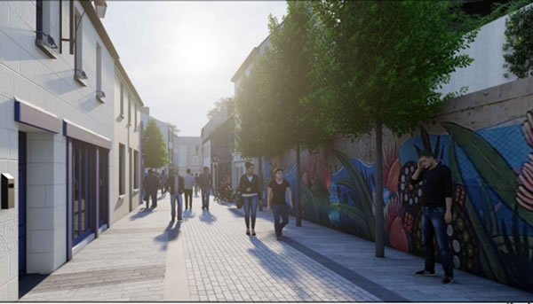
This project aims to create a dynamic, inclusive, and vibrant public realm along St. Mary’s Lane that respects and celebrates the historical and cultural significance of the area. The initial concept design integrates stakeholder research, aiming to enhance public spaces and connectivity while preserving the area's historic character. Improvements include better lighting and signage for the link between the Tholsel and St Mary’s Lane, and repairs to historic walls with sensitive conservation methods. Soft landscaping and drainage solutions will be integrated, respecting existing archaeology and fabric. An artwork strategy will reflect the area's history, incorporating elements into paving, thresholds and walls. Public and feature lighting will be designed to avoid clutter, using wall-mounted and discreet pavement lights to highlight key areas.
The design will create durable, low-maintenance, high-quality and cost-effective infrastructure. Visual quality, carbon footprint, and material suitability in a heritage context will be carefully considered, balancing these factors against initial and long-term costs. A minimal palette of local materials will be used, incorporating existing paving patterns while ensuring safety and ease of maintenance. Key areas, such as the entrances to the Medieval Mile Museum, will feature high-quality materials, used sparingly to highlight their significance. The project will prioritise conservation-led repairs over replacements for historic elements. This approach will enhance the historic character of the area, avoiding modern composite materials and methods. The design philosophy emphasises minimal intervention, retaining rather than replacing historic fabric and limiting demolition. New elements will be designed to complement the existing conditions while maintaining a modern appearance.
St. Kieran’s St. Urban Enhancement Scheme
St. Kieran’s Street is set to be developed as a high-quality public realm area with superior hard and soft landscaping. The project will consider existing and future uses, focusing on creating a people-centred space and extended pedestrianisation. The current paved surface will be replaced and decluttered to enhance pedestrian safety. Outdoor dining, a key element in creating ambiance, will be enhanced. Clear guidelines for outdoor dining extents will be established, alongside provisions for public seating in wider sections of the street. Public sheltered areas will be incorporated.
Currently, St. Kieran’s Street consists entirely of hard landscaping, the introduction of soft landscaping features like trees and raised beds in wider areas is planned. Existing heritage-style lighting will be supplemented with feature lighting to enhance the evening atmosphere and night-time economy.
John’s Quay and John’s St Urban Design Strategy
John's Quay is a site rich in historical anecdotes and significant events that have shaped its character over the centuries. The quay's origin is humorously linked to the construction of the Kilkenny Canal. To secure a government grant, the canal committee needed to demonstrate that the river was in use. A boat was reportedly transported overland and docked on the east bank of the river, turning the "quay" into a local jest. Whether this tale is true or not remains uncertain.
The Nore River has a history of destructive flooding in Kilkenny. Notable floods include the destruction of Green's Bridge in 1487 and St. John's Bridge in 1584. The most devastating flood occurred on 2nd October 1763, destroying both bridges and causing property damage worth £11,000. The name "the Lake" originates from these floods. Today, the lake area lies between Michael Street and the river. In the 18th century, this area was low-lying grassland between the river and the old mill stream, which flowed from Green's Bridge past the library. When water levels rose, this area flooded, giving rise to the name.
St. John's Bridge, which opened on 21st November 1910, was designed by L.G. Mouchel and constructed by J and R Thompson. At the time, it was the largest single arch bridge made using the then-new method of reinforced concrete construction. Spanning 43 metres, it replaced an 18th-century bridge and stands on or near the site of bridges dating back to the 12th century. Buildings of historical significance include Evan's Asylum, also known as Evan's Home, which was established in 1818 by the bequest of Joseph Evans of Belevan, Ballyfrunk and The Home Rule Club, founded in July 1894, previously the Nore View School, established before 1840. The Lake School, which opened in 1908, was the first school for infants and girls in the area. The current school building dates back to 1937.
This historical context underpins the significance of John's Quay, reflecting its evolution and enduring importance to the local community. Kilkenny County Council now plan to produce an Urban Design Strategy for the John’s Quay/John Street area to guide its development into the future.
Transport Infrastructure
Road Network
Northern Ring Road Extension and Western Environs Connectivity
Kilkenny County Council is progressing the Northern Ring Road Extension (R1) with the Department of Transport. The Northern Ring Road extension is a key connection to the Cork Rd, the M8, and this connectivity will reduce the through traffic in Kilkenny City, in particular freight traffic. Kilkenny County Council is investigating options to enhance connectivity from the western environs to Freshford Road. These projects are critical objectives within the Kilkenny City Development Plan. Appraisals of all options will be conducted during future stages of the application process to analyse the associated benefits, costs, and potential risks. The progress of the projects is dependent on continued funding from the Department of Transport.
Public Transport
City and Regional Bus
City Direct operates two routes in Kilkenny City. Route KK1 runs from Loughboy Retail Park to the N77 Roundabout and serves Upper Patrick Street, MacDonagh Junction, and Castlecomer Road. Route KK2 runs from Purcellsinch to St Luke’s Hospital with stops at Dublin Road, Newpark Shopping Centre, MacDonagh Station, Nowlan Park, and Loreto. The routes share a path through the city centre, and operate every 30 minutes Monday to Saturday. Services on Sunday operate by the hour, with services every half hour during the core part of the day. Late night services operate on Friday and Saturday nights. Kilkenny County Council are working with the NTA to identify options for expansion of the service, to include more direct routes, additional routes and more frequent services.
Rail: Revised Timetables, Future Expansion and Permeability Link
Irish Rail operates MacDonagh Station. The station adjoins MacDonagh Shopping Centre and is located at the top of John St, close to the city centre. It is approximately 700m to High St. or Kilkenny Castle. The station is on the Dublin-Waterford route, with connections to Cork, Limerick and Galway. Future plans include a dual track for the Kildare - Kilkenny line, this would greatly increase the capacity for more frequent services and allow more commuter services to serve intermediate stations and thus enable intercity services to deliver faster city to-city journey times.
Bike Share Scheme
Bike Share Scheme
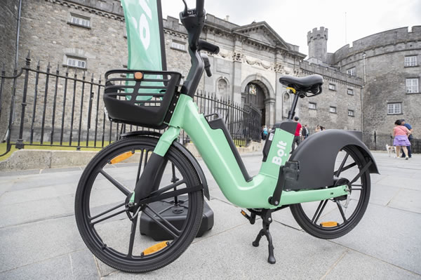
Kilkenny became Bolt's second regional e-bike scheme in August 2022. The Bolt e-bike scheme was the first of its kind in the South East. This service helps Kilkenny County Council to provide alternative transport options and the availability of electric bikes play an important role in reducing the reliance on private vehicles when travelling short to medium distances. To rent a Bolt e-bike, users need the Bolt app, available on app stores, and a payment card tied to an account. There are currently 49 parking locations in Kilkenny and as of August 2024, over 120,000km have been travelled by users.
Car Share Scheme
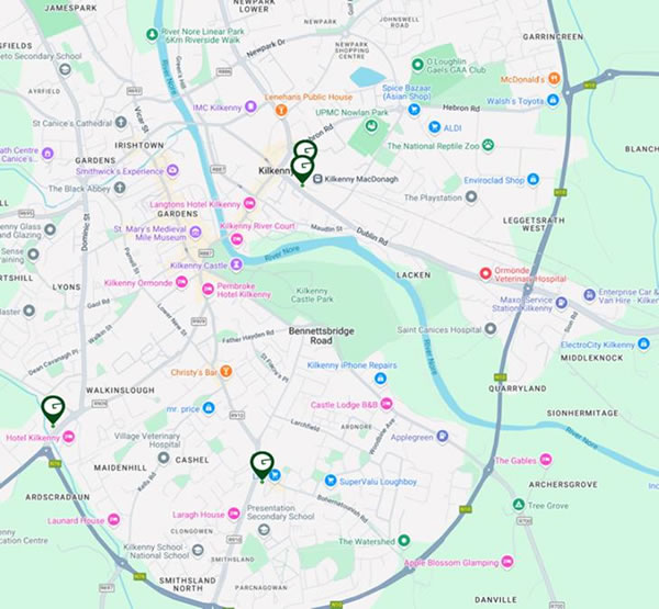
Go Cars are available at 4 locations in Kilkenny.GoCar is Ireland’s largest car and van sharing service, with over 1000 vehicles available to book by the hour, nationwide. For more information, visit the GoCar website:
Park and Strides/Rides
Park and Strides/Rides
Kilkenny County Council is advancing efforts to improve accessibility for residents in rural areas and the wider catchment by exploring Park and Stride and Park and Ride initiatives. Key locations under consideration include sites along Hebron Road and Castlecomer Road.
Park and Strides/Rides offer rural residents and commuters convenient parking on the outskirts, reducing the need to drive into the town centre. Encouraging the use of Park and Stride/Ride helps ease traffic in Kilkenny’s core, making travel smoother for everyone. Fewer cars in the centre means lower emissions and improved air quality, while Park and Stride encourages walking, promoting better health.
These initiatives integrate seamlessly with Kilkenny’s broader transport network, catering for those who wish to car pool, cycle, walk or use the bus for the last part of their journey.
Multi-modal Hubs
Multi-modal Hubs
Kilkenny County Council is exploring the potential development of multi-modal transport hubs. These proposed hubs would serve as central points for various transport options, including bike and car-sharing services, and electric vehicle charging stations.
Strategic locations will be selected, such as next to the train station or regional bus services, to provide for seamless connectivity between rail services and other modes of transport, making it easier for residents and visitors to navigate the city and surrounding areas. The hub aims to enhance sustainable travel options, reduce reliance on private vehicles and improve overall accessibility.
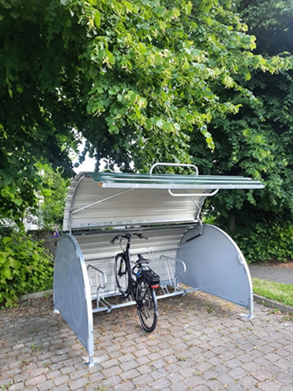
Secure Bike Parking
Secure bike parking provides a safe storage solution for people living in attached houses or apartments with inadequate storage space for bikes. Having to store bikes inside houses or manoeuvring through houses can act as a barrier to people cycling.
The staff of Newpark Family Resource Centre and the Presentation Primary school are delighted with the bunkers and the donated bikes they have received which now ensures all children have access to a bike.
Bunkers have been installed in Rose Hill, Newpark Crescent, Newpark Family Resource Centre and the Presentation Primary School, Parnell St.
Active Travel
Pedestrian Improvements
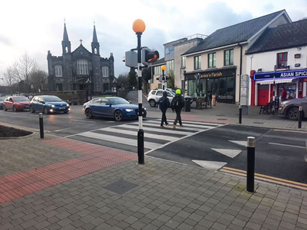
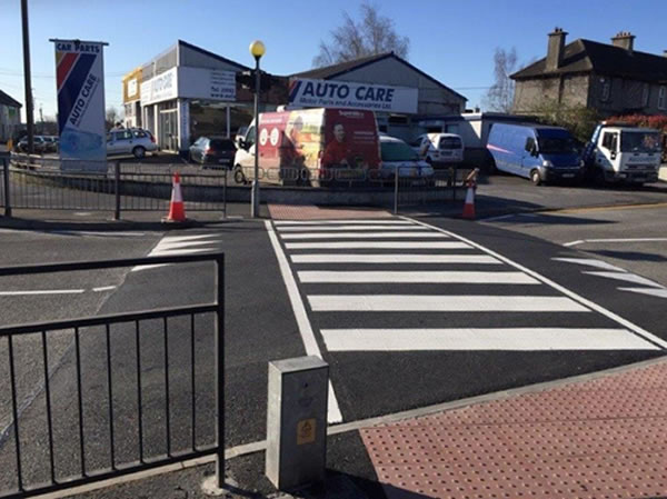
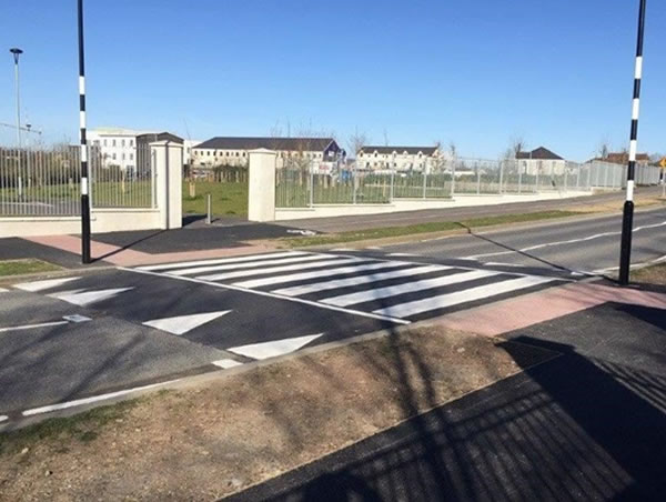
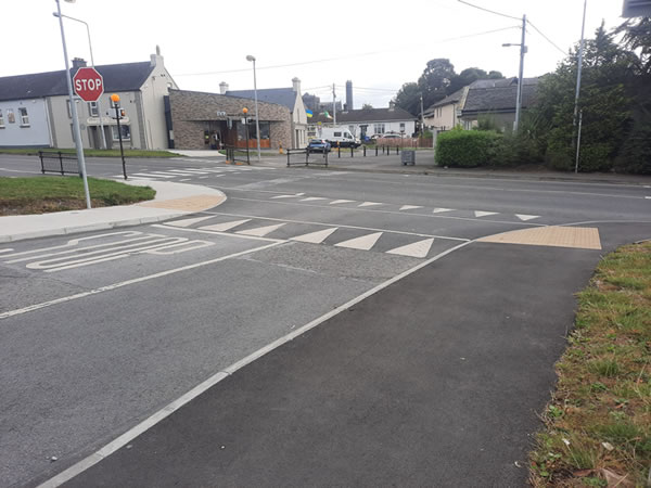
The walkability of urban environments is dependent on safe crossing points. Under the Active Travel programme, many crossings across the city have been installed or upgraded in recent years at key crossing points. This includes Dean St, Bohernatounish Rd, Penneyfeather Way and Dominic St. in the vicinity of schools. A new crossing has also been installed on Nuncio Rd with an incorporated sustainable urban drainage system. As well as providing safe crossing points, raised crossings act as traffic calming measures, slowing vehicles down.
A further traffic calming measure is junction tightening, where the radius (how sharp the turn is) of a junction is reduced. Large corner radii encourage vehicles to turn at high speeds and are hostile environments for people walking, wheeling or cycling. The tighter junctions improve visibility, slow traffic speeds and reduce crossing distances.
Safe Routes to School
Radial Routes Scheme
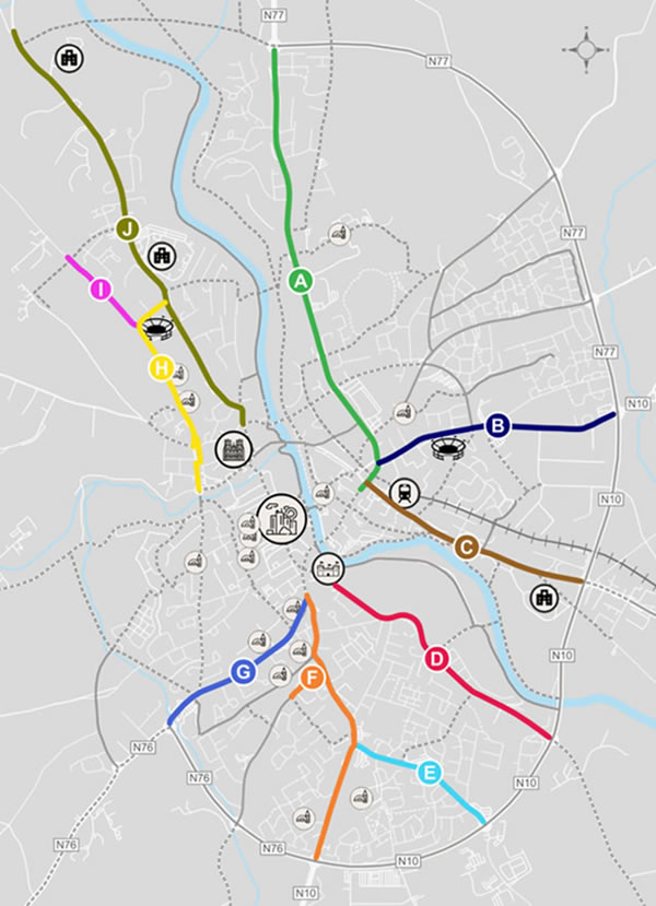
This strategic scheme will be progressed by Kilkenny County Council on a phased basis from 2024 to 2030, through funding from the National Transport Authority’s Active Travel programme.
Construction is underway on the first route, the Freshford and Granges Road. Approximately 3,000 school-age children will commute to school along the Freshford or Granges Road. Safe, segregated facilities will allow students to walk, wheel or cycle to school. The Freshford Road is a key link to St. Luke's and Aut Even Hospital, one of the largest employers and trip generators in Kilkenny City. Thomas Square provides a low traffic shortcut from the Granges Rd to Dean St and on to the city centre via Abbey St.
The Waterford and Bohernatounish Road is currently in the design stage. This busy corridor links residential areas to the Presentation Secondary School, Gaelscoil Osraí and Kilkenny School Project. The route also serves the shopping centre, medical services, The Watershed and large employment centres.
Other routes under planning include the Castlecomer Road to MacDonagh Junction, the Hebron and Dublin Road that will link to the off-road path by the Nore and the St. Canice’s site, the Bennettsbridge Rd and the College Rd.
Ring Road Crossing Facilities
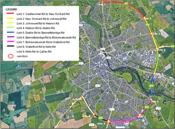
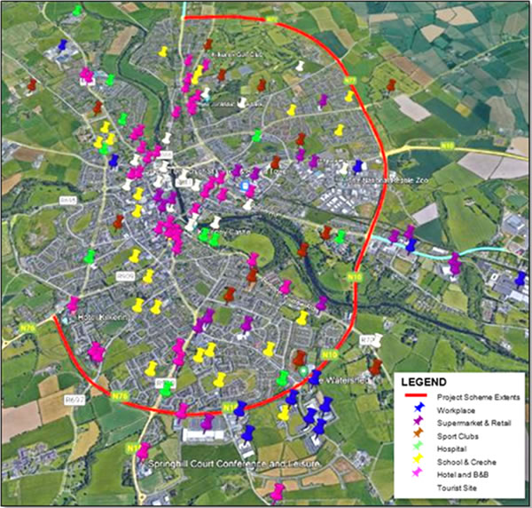
This project aims to upgrade the pedestrian and cycle facilities along Active Travel links and provide new pedestrian and cycle infrastructure on roundabouts/junctions in order to provide safe alternatives for vulnerable road users. It will enhance accessibility to the city centre, key employment destinations, education, residential areas, and other services. There is opportunity to improve existing pedestrian and cycle facilities along the urban side of the Ring Road. This scheme will enhance mobility in Kilkenny City and align with the 10-minute city concept. It aims to
- Encourage a shift to sustainable modes
- Support decarbonisation
- Encourage independent journeys for all
- Address transport inequities
- Provide opportunities for increased physical activity and associated health benefits
- Enhance wellbeing of those living adjacent to and accessing services along the ring road. The scheme will be delivered in a number of phases, with the busiest junctions being prioritised.
Coote’s Lane
Coote’s Lane provides a walking, cycling and wheeling link from Upper Patrick St to the Callan Rd and is soon to be enhanced by the addition of a bridge over the Breagagh River, providing direct access to the Ring Road footpath and cycle track. The project is part of Kilkenny Active Travel, Safe Routes to School programme and will provide a mainly off-road link with residential communities in the Kells Rd/College Rd and Callan Rd areas to St. Patrick's De La Salle and John of Gods National Schools. With inspiration from local school children, there has been some conservation and renewal works to Coote’s Lane. Pollinator friendly planting includes the addition of ivy, red clover, heritage apple trees and native hedges to provide shelter and nesting sites for birds, insects and small mammals and act as natural corridors for wildlife movement. A mural inspired by the local schoolchildren and Cartoon Saloon’s Wolf Walkers adds vibrancy and colour to celebrate our precious pollinators and biodiversity.

Greensbridge Active Travel Facilities
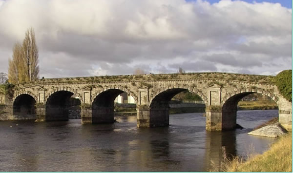
Greensbridge, originally constructed in 1766, is a multi-span masonry arch bridge forming the northern most crossing point of the River Nore in Kilkenny City. The bridge is formed of cut limestone with ornate detailing which was modelled on the Ponte Di Tiberio bridge in Rimini in Italy. In 1969, the bridge was modified with the addition of a pedestrian walkway parallel to the existing carriageways. The northern masonry parapet was removed at this time. The narrow walkway creates an unattractive crossing in close proximity to high traffic volumes for pedestrians. In addition, there are currently no dedicated facilities for cyclists on the bridge. In September 2022, Kilkenny County Council appointed AECOM to conduct a feasibility report on the provision of active travel facilities at Greensbridge, to include environmental and technical appraisals. The project will undergo a preliminary business case.
A pedestrian and cycle link at Greensbridge will improve permeability in an east-west direction over the River Nore and provide greater links to Kilkenny City. This project will encourage a shift in transport modes to more active travel, contributing to tackling climate change and improving connectivity between communities on both sides of the river. It is expected that the preliminary design will go through the planning process in 2026.
Pococke Park
Useful Links
- Read about the consultation process to date
- View the most recent report on the draft SUMP vision, objectives, and measures
- Get answers to some Frequently Asked Questions
- Get information on other Travel and Transport projects happening in Kilkenny

 Kilkenny County Council
